What stands beside the road we drove, positioned, with the photograph behind each value.
MapMap Roadside is a positioned inventory of what stands beside the road on the segments you commission: signs, markings, nameplates, lighting columns, kerbs, shopfronts. Each feature carries a dated evidence chain back to the frame it was read from. We make no claim to national coverage.
No form, no login: a public kilometre of the record, exactly as delivered.
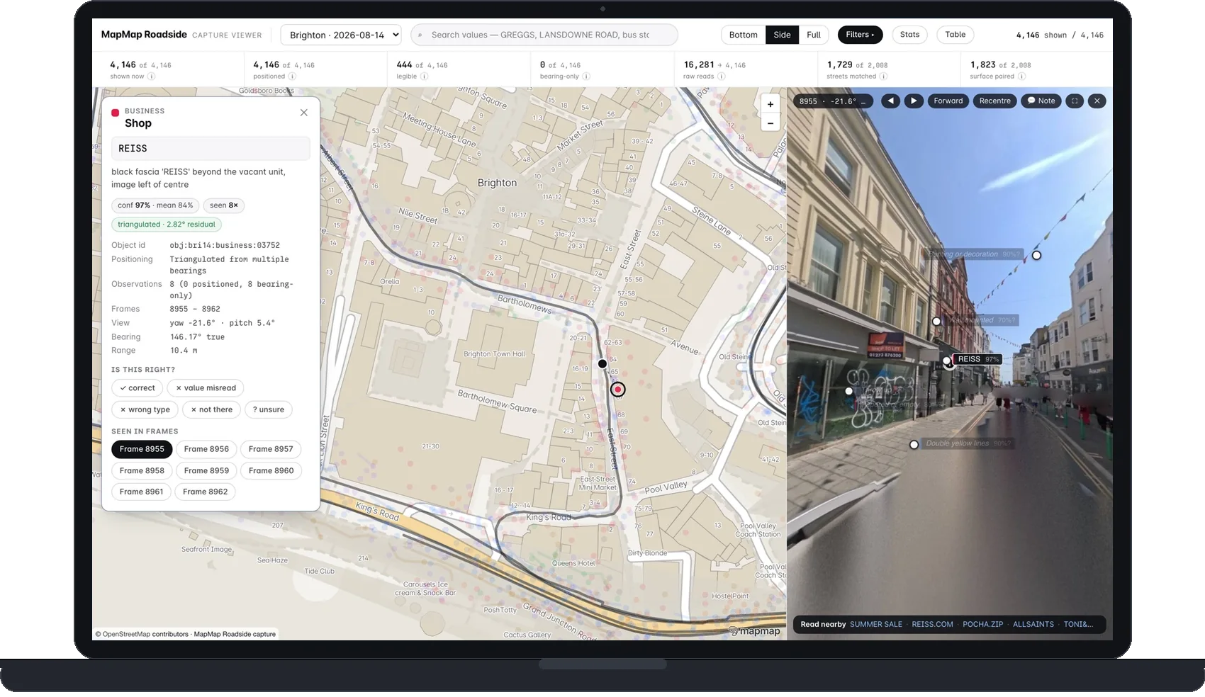
This is the whole product in one row.
A record from the Brighton & Hove pass, exactly as it stands today. The reading is done; positioning, map matching and the human review sample follow as the pass moves through processing, and each stage is recorded against the feature when it completes. Where a value cannot be read, the record says not legible and never guesses.
A completed record adds the triangulated position, the OSM way it belongs to and the outcome of review. When a read disagrees with the map you already hold, the record carries the frame that settles it.
- feature
- regulatory · no-entry roundel with supplementary plate
- value read
- No entry except cycles(legible)
- source frame
- f8619, North Street, Brighton
- captured
- 14 August 2026, pass 01
- position
- in processing(triangulation follows the read)
- network reference
- in processing(map matched on delivery)
- review
- human sample pass runs before delivery
A kilometre of it is public.
The seafront kilometre of the Brighton & Hove pass is served openly, as a live extract of the same record we deliver: 4,146 positioned features, 3,411 carriageway defect reads, and 2,008 blurred photographs with every evidence link working. The viewer is the product, scoped to one drive on one date.
Click any feature and it answers with the frame it was read from. What the extract excludes is not hidden behind the interface: it was never packed, so there is nothing to find. Counts describe this extract, not the full 54.9 km capture.
Coverage is the wrong question.
Imagery at national scale is a solved and crowded problem, and we would lose that contest on day one. The question a highways team actually has is narrower and harder: what is on this street, where exactly, and can you show me? So Roadside is built as a survey record rather than a picture library. Every extracted feature is positioned, tied to a network reference and linked to the dated frame it was read from.
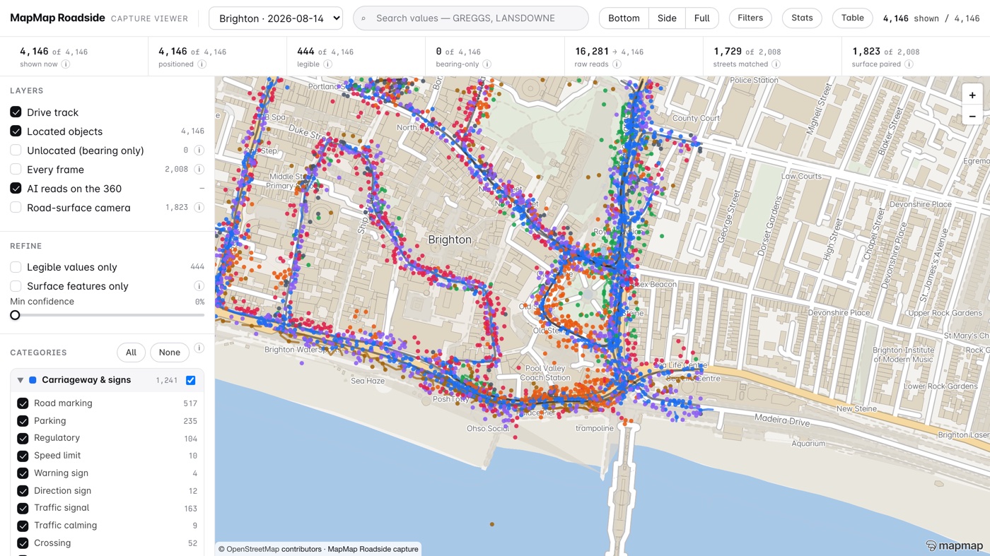
The street, as a register
Signs, road markings, street nameplates, lighting columns, street furniture, boundaries and materials, trees, utility covers. One layer per asset class, each feature with its evidence link.
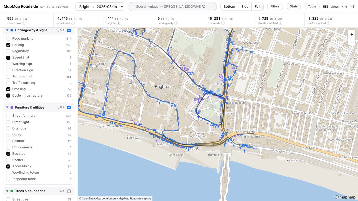
The kerb, as it is used
Dropped kerbs, tactile paving, crossings, parking restrictions, loading and waiting, EV and cycle provision. The layers that decide schemes and get argued about at committee.
The high street, dated
Shopfront and unit condition with a dated photographic record per address, for vacancy and high street work where the date on the evidence is the point.
How a thing on the street becomes a record.
Order matters here, so the stages are numbered. Each one is reproducible from the stage before it, which is what makes the evidence chain hold.
Pass
One drive of a segment on one date, captured at survey spacing. A pass is the unit of work: you commission a pass, and a later pass over the same segment is what produces change.
Read
Frames are read for features and, where the text is physically legible, for values. Faces and number plates are obscured before anything is shared or delivered.
Position
Each feature is placed by triangulation across frames where the geometry allows, and by ground projection or ray casting where it does not. The method used is recorded against the feature, not averaged away.
Reference
Features are map matched to the road network so they arrive attached to a way you already hold, rather than as loose points you have to reconcile.
Review
A human sample pass is run over the readings before delivery, and its findings feed back into the next read. What the sample supports is what we will say in writing, and nothing beyond it. On the first surveyed town that sentence reads: legible-value precision of 98.0% (245 of 250) on a seeded, reproducible stratified sample, with a 95% confidence interval of 95.4% to 99.1%. It measures whether values we claimed to read were read correctly, and nothing else. It is not a positional accuracy figure: how close a feature sits to its true position is not yet measured, and we will not imply one number covers both.
A second camera reads the road itself.
The 360 rig looks outward at the street. A second, road-facing camera runs alongside it, capturing a geotagged frame of the carriageway roughly every 4 metres of the drive. Same vehicle, same pass, no extra visit: the Brighton & Hove pass carried 13,610 of them.
Each frame is read the way the rest of Roadside is read: findings, not guesses. Cracking in its families, worn markings, patches and reinstatements, ironwork, edge fretting, and the highway inspector's own painted marks, read back as records. Every observation carries a class, a position, a confidence and a graded severity, and links back to the frame it was read from. Severity is a visual grade made for prioritising an inspection, not for replacing one.
The same readings can steer routing: our router already uses them to pick smoother cycle routes. The demo below scores two bicycle routes between the same points against the Brighton pass.
Open the cycle routing demo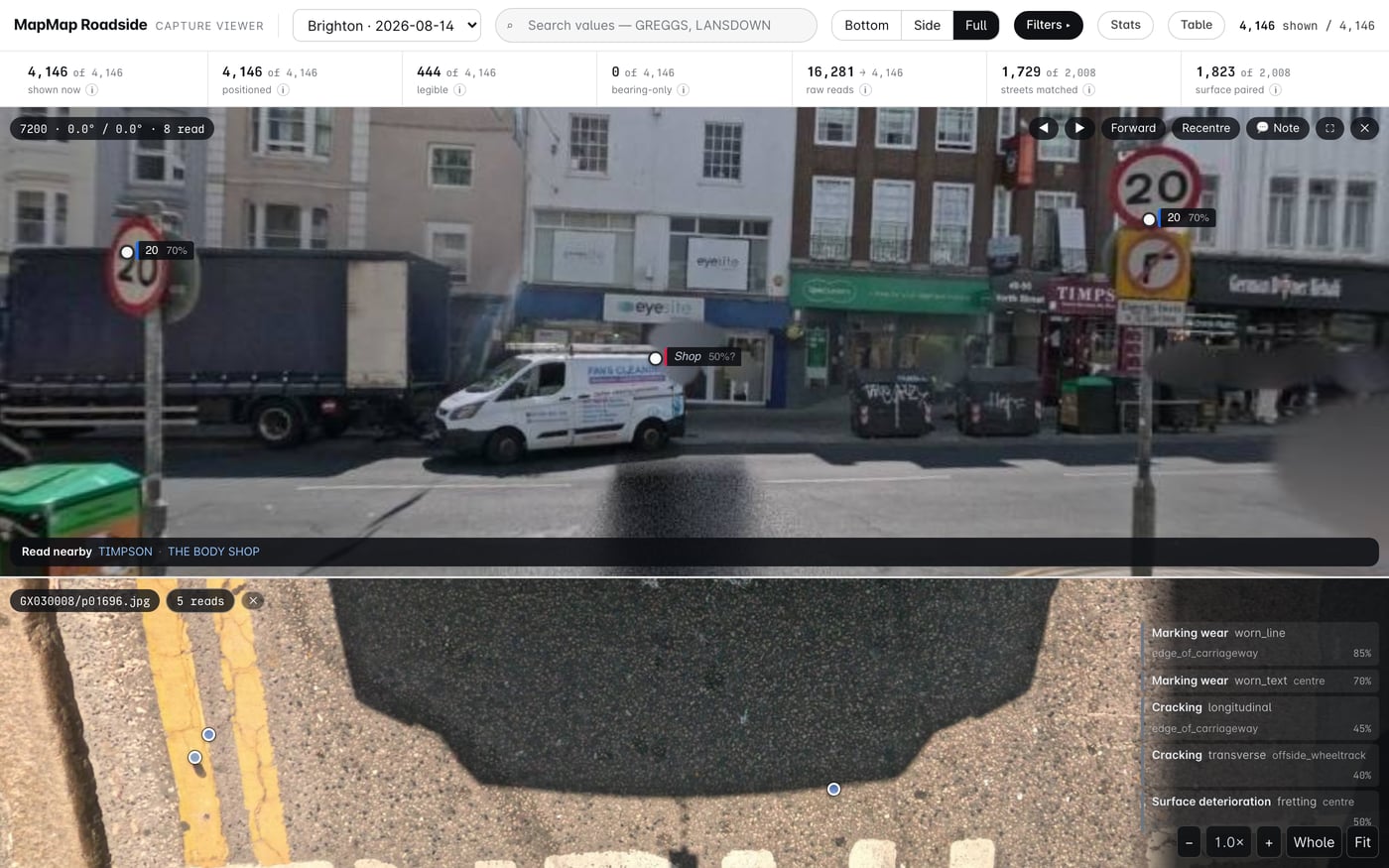
What arrives, and in what form.
Layers you can open
One layer per asset class, in British National Grid, with a data dictionary and stable feature identifiers so a later pass lines up against this one.
See the data dictionary →A link per feature
Every record links to the frame it was read from, held on our side. Your system stores the record and the link, not the imagery.
A method and QA statement
Written up per delivery: how it was captured, how positions were derived, what the review sample covered, and where the honest unknowns are.
Contractor access included
Your term maintenance contractor and consultants can use the data for your scheme by notification, not by asking our permission.
Start with a street, not a signature.
Ask and we will walk you through a live demo of the record on ground we have already surveyed, then send you a desk proof to keep. Both are free. A drive proof on your own network is the next step at £2,500, credited in full against any package you go on to buy. Judge the record before anyone talks about money.
| Package | Price | What it covers |
|---|---|---|
| Desk proof | No charge | A street we have already driven, extracted and delivered as you would receive it. |
| Drive proof | £2,500 | Two kilometres on a street you nominate, captured and extracted for you to judge. Credited in full against any package bought within 90 days. |
What this is not.
Kept on the page rather than in the small print, because a survey record is only worth what its caveats are worth.
Roadside is asset inventory and evidence. It is not a statutory carriageway condition survey, and we do not hold the accreditation that would let us present it as one.
Carriageway condition has its own road-facing camera and layer. Severity is a visual grade for prioritising an inspection, never a measured depth, and open-pothole detection is undemonstrated.
We make no claim to national coverage and do not sell by area covered. What exists is what has been driven, and each pass says where it went.
A value is only recorded when it can be read in the frame. Distant and obscured features stay as honest unknowns, and a later pass may resolve them.
Not yet measured. The precision figure we publish is about whether a value we claimed to read was read correctly, and it says nothing about how close a feature sits to its true position. When a positional figure exists it will be published the same way, with its sample and its confidence interval.
Multi-pass change reporting is in build. Until it ships, a re-survey is delivered as a fresh dated pass rather than an automated difference.
Frames are held by us and reached through per-feature evidence links. Publication of any imagery is gated on our data protection assessment and is not offered by default. What is captured, how it is blurred and how to ask for a frame to be removed are set out in the imagery notice.
Roadside imagery notice →Want to know more?
If Roadside looks useful for your patch, get in touch and we will take you through it, specimen record included. Imagery is captured by us, obscured before use, and licensed rather than transferred.